Don’t hesitate to contact us:
Forum: discuss.graphhopper.com
Email: support@graphhopper.com
We have released the next version of GraphHopper, the flexible and fast open source routing engine for OpenStreetMap. Read more about it on GitHub and read on to find out what’s new.
The route calculation for the flexible mode got up to 30% faster! Great rework from @easbar (#2571 and #2600).
And for the flexible mode the alternative route finding algorithm got a lot faster due to a bug fix (#2603).
The internal architecture with the BaseGraph, TagParsers and EncodingManager classes was heavily refactored by @easbar. It was finally possible to remove the FlagEncoder (#2561, #2611, #2619) and also some other legacy classes (#2540, #2541, #2542, #2550, #2551, #2559, #2567, #2606).
This work makes the handling of vehicle profiles with all the customization possibility easier.
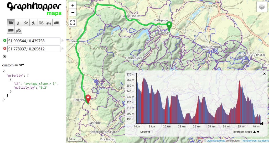
Due to the aforementioned refactoring and with changes like #2568 and #2594 the custom_model profile configuration got much more powerful. Additionally there is now the urban_density encoded value (#2637), and a max_slope and average_slope (see image above and #2645). Combined with the “roads” vehicle you can model e.g. waste collection vehicles which, under certain conditions, are allowed to do unusual things like use footways or drive oneways in the opposite direction. Or your vehicle can consider elevation changes to avoid or favour them or to change the speed.
All these new possibilities deserve a separate blog post which is coming soon.
The deployment guide was updated (#2576). See also our blog Host Your Own Worldwide Route Calculator With GraphHopper.
Instructions now contain the destination information from OpenStreetMap making route guidance for cars more descriptive. So instead of “Turn right” the instruction now reads e.g. “Turn right and take A 4 toward Dresden” – see this example on the maps. (#2597, #2598, #2632, #2622, #2624)
The time and distance values of the path details and instructions are now consistent with the global time and distance values of the path. See #2626.
Along with many smaller bug fixes and enhancements we merged more than 45 pull requests since we released the last version 5.0 in March. Thanks a lot to all contributors:
easbar, boldtrn, otbutz, karussell, michaz, ratrun, RafaelSTelles, PanCakeConnaisseur, lukasalexanderweber
You can see it in action on graphhopper.com/maps, or install it locally on your laptop or server. Do not hesitate to ask questions or leave feedback in our forum.
Happy routing!
